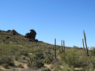
Dinosaur Wash is a great hike, accessed from Sophie's Flat near Wickenburg (though you can also access it from the other end)
 |
| Ocotillo, about the only thing blooming in mid February after a dry winter |
 |
| Doesn't that rock formation look like a rabbit? |
 |
| The most dangerous wildlife I saw. You can't see the bees much in the photo, but they were sure buzzing. And look at that honeycomb! |
 |
| Some of the fun dry wash hiking Almost like mini slot canyons |
 |
| A mine shaft just past the coolest, rock-scrambliest, part of the wash |
This is a very fun trail, first through very pretty Sonoran desert trails that cross washes, climb small rises for good views, and weave past interesting rock formations. Then you get into the wash, which brings its own interest, especially the mini red slot canyons and bits where you have to scramble up or down rocks. When calculating distances and times, factor in the extra effort of walking in the sand.
Take Constellation Road northeast from near McDonalds in Wickenburg. When the pavement ends, it turns into a good dirt road, suitable for most cars. Just be careful of the ATVs out and about. After about three miles, turn left on Blue Tank Road (there are signs for Sophie's Flat). It's less than two miles on another pretty good dirt road to the trailhead, which has an outhouse, picnic table, and room for dispersed camping. Hint: on the way, there's a hairpin turn where a wash beckons at the bottom and where you'll often see people parked with their trailers and ORVs. Park and walk a bit up the wash. It's a much more accessible wash with cool rock walls.
Length:
Somewhere around 8-12 miles, depending on where you start and how far you go in the wash before turning around.
Difficulty:
Moderate. There's not a lot of elevation gain, but it's not boringly flat either. The trails's fairly well marked. There is a lot of walking in sand, which simply takes more effort. And beware of cholla on an around the trail. Wear good boots and consider sticking a cactus-removing comb in your backpack. Always be sure to take plenty of water and do not hike this in the heat unless you are a seasoned desert hiker. There's very little shade.
Route:
I started where the A trail crosses Blue Tank Road and turns quickly into the C trail connector. When the C connector gets to the other side of the A loop, I went left. I took the D spur north to the wash, then followed the wash left (west) for around 1.5 or 2 miles until a little past the mine cave and some slick rock scrambling. Apparently if you go about a mile further you can get all the way to Box Canyon and Mistake Mine, but I was going to run out of daylight (I got a late start after lunch). I returned via the trail that appears to be on State Trust Land (permit required) and then part of the A loop back to the C connector, then to the B connector, then to the A loop to the outhouse at the trailhead. I made it back to camp just as the sun was setting. A great hike.
No comments:
Post a Comment